Access: The Power of Paper Maps
Originally posted on November 24, 2017 at 1:11 amBy Brian Fox, United States Geological Survey
Mapping is important these days. Maps are critical to helping people discover the closest coffee shop, navigate to a new place or, in our case, discover and experience new trails. Maps, to me, mean anything from the latest app on your phone (like MTB Project) to that folded cartographic product you carry in your pack. Both do the same thing: help you explore trails on public lands. Maps may be one of the most important accessories for a mountain biker, as they answer the question, “Where should I go ride?”
To that end, there are some great maps to help you find and explore trails. One of my favorite ways to discover mountain bike trails is with MTB Project. The website makes it easy to find trails and identify their level of difficulty, helping you plan your next mountain biking adventure. Their mobile app puts that planning capability in the palm of your hand, with the benefit of monitoring your progress along the way. But the age-old paper map is a great way too. In fact, it doesn’t rely on batteries, it can be waterproof and it can help us develop important map-reading skills.
To use a paper map, you’ll need the skills to do it. Map-reading skills can be learned through courses provided at a local outdoor co-op, the National Geographic Society and online. Map-reading skills are important to develop and maintain, and not just so you don’t get lost. There’s actually a portion of our brain that is devoted to spatial awareness, and studies have shown that with the increasing use of GPS-based navigation tools, this part of our brain is getting smaller. So while you’re on your bike developing cardiovascular strength, you can use a paper map and develop your brain as well.
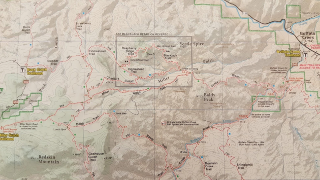
As long as we’re talking about maps and map reading, we should review some map products that are available for a popular mountain bike destination. I happen to live in Denver, and a local recreational hotspot is Buffalo Creek. In looking for some maps of Buffalo Creek, I found some great products from four different producers: the U.S. Geological Survey (USGS), National Geographic, Singletrack Maps and Jefferson County.
USGS U.S. Topo
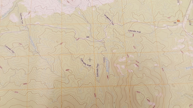
The USGS produces the U.S. Topo map, a 1:24,000-scale map product that is available for all of the contiguous U.S. and Alaska. These maps can be downloaded for free via The National Map and either printed or used on a mobile device that reads a GeoPDF file format (Avenza’s PDF Maps or Terrago Edge, for example). The USGS is making these modern U.S. Topo maps with a lot of help from automation, remapping the country every three years with a handful of staff to ensure that the public has access to the latest map content. Considering that the initial U.S. Topographic map program took four decades and thousands of cartographers to complete, the modern version at USGS is a technical marvel.
The USGS’s U.S. Topo maps are currently based on a fixed 7.5-minute grid that covers the entire U.S. This allows the USGS to focus on consistent, national production of a large-scale (read: large detail) map with coverage throughout the U.S. While this may require users to have multiple U.S. Topo maps to have complete coverage over a particular recreation area, the USGS maps are available for some remote places that may not be covered by private map producers. The U.S. Topo maps are also general-purpose topographic maps, so they don’t provide details like trail difficulty, which may be important to specific user groups.
The U.S. Topos are a constantly evolving product, featuring a growing number of geospatial features. The underlying elevation contours and water features on U.S. Topo are managed by the USGS through the 3D Elevation Program (3DEP) and hydrography programs, respectively. 3DEP and the National Hydrography Dataset (NHD) not only help make some beautiful maps, but also help drive geospatial analysis critical for understanding the impacts of climate change, water quality and other scientific studies. The trail data on them is provided by a number of sources, including MTB Project, thanks to an innovative agreement between IMBA, REI and the USGS. Federal agencies like the USDA Forest Service, the National Park Service and the U.S. Fish and Wildlife Service are also providing trail data to USGS that is published on the U.S. Topo maps.
While USGS provides free maps and map data for the U.S., there are a number of other organizations out there making some beautiful maps to help you find your next adventure.
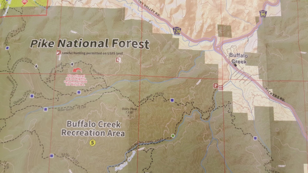
Jeffco Outdoors Foundation Region 7 Map
Many state and local governments create maps of their parks to help expose the recreational opportunities available to the public, and the Jefferson County Regional Series maps are a great example. While the Region 7 map over Buffalo Creek is the smallest-scale product in this “review,” showing the least amount of detail over the area, it does a good job of highlighting the trails along with their relative difficulty. It includes elevation contours without any hill shading, with the colors on the map used to highlight land-management boundaries. Trailheads, bathrooms and camping are also featured on the map. Overall, the map does its job well, highlighting recreational opportunities to the public, and I think this particular example demonstrates the importance of looking at state and local information sources as you plan your next ride.
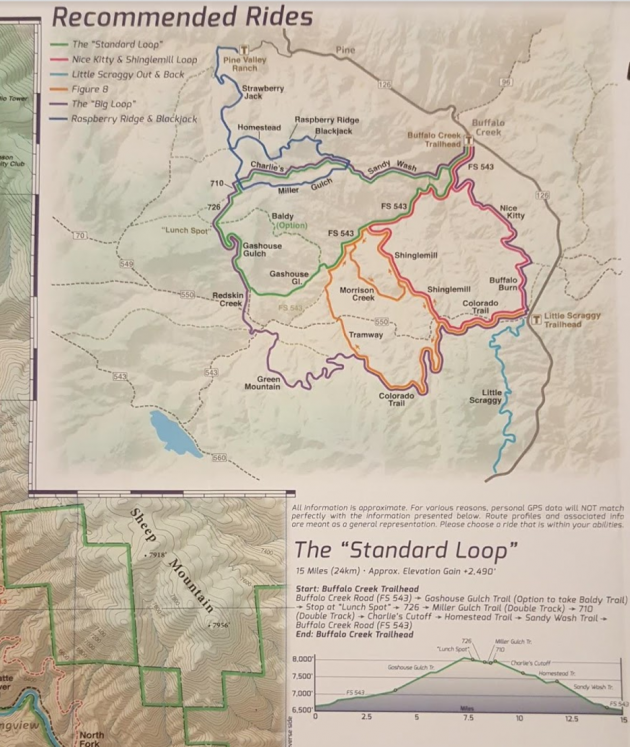
National Geographic (NatGeo) Buffalo Creek Mountain Bike Trails
The NatGeo map of Buffalo Creek, like all NatGeo products, is beautiful. Overall, the map is easy (and fast) to read. Upon first glance, the trails, trailheads, camping sites and other recreational features pop, while the elevation and water features are subdued. Although the elevation contours are muted, the contours are regularly marked, ensuring easy referencing of height. The trails are well labeled, with names and relative difficulty clearly marked as well. Landforms, elevations and names are also labeled, ensuring the user can identify the mountains they are riding by.
According to Eric Janota, product manager at National Geographic, this map is designed specifically for mountain bikers. While NatGeo creates a variety of maps to support tourism and recreation, this particular map is handlebar width to ensure it is not too unwieldy when unfolded on the bike, but also designed to fold and fit in a jersey pocket. It is printed on waterproof paper, and the map’s format is one of the smallest of the group, making it easy to handle while out on the bike. That said, its 1:30,000 scale provides plenty of detail.
Janota highlighted that while the USGS’s elevation, hydro and geographic name data were critical to making this map, they collected their own trail data over the recreational area. They worked with the Colorado Mountain Bike Association (COMBA) to help determine the best routes and experiences throughout the recreational area. In fact, while the front side of the map focuses on the physical features, the flip side highlights the potential experiences you might consider. Four inset maps are shown, with six possible experiences laid out, each with its own elevation profile, distance and other important stats, highlighting the potential effort involved and helping you choose the right ride.
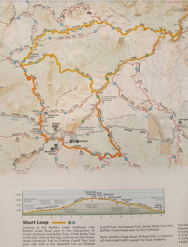
Singletrack Maps Buffalo Creek Trail Map
Singletrack Maps is a map producer from Salida, Colorado. They have a variety of maps covering popular recreational areas throughout the state, many of which are ignored by larger map producers. Their Buffalo Creek Trail Map is colorful and easy to read. It is smaller scale and a larger format than many of the others, providing users with trail information outside of the immediate Buffalo Creek recreational area. The map includes well-marked trails, with both the difficulty and names indicated. The brightly labeled trailheads quickly orient the user to potential starting points for a ride. While the map is smaller scale than many of the others, it features a lot of details while not being too noisy or cluttered.
Besides the map, there is an inset with recommended rides, highlighting various experiences riders can consider depending on their endurance and time available. It provides elevation profiles for each of these route options. With this information on the same side as the map, the need for the user to flip the map back and forth to reference this valuable data is minimized.
Singletrack Maps collected its own trail data and organized the trail experiences illustrated on the map, with the underlying elevation, hydrography and landform data coming from the USGS. Farid Tabaian, owner of and cartographer for Singletrack Maps, believes that “field checking the trails … help[ed] me add detail to the map, like gates, bridges, trail difficulty, etc.” Clearly, making a map is an art form. “Being a trained cartographer, there are levels of detail and diligence that cartographers go through to create a beautiful end product,” he says. “There is a great power [in] being able to manipulate and edit even the background data to create a level of visual hierarchy that most map read[er]s will not notice, but it makes the map easy to read and gives the most important information to the reader.”
Maps help you Opt Outside
It is important to carry a map, especially on new trails, longer rides and backcountry experiences. That map can include your mobile device, but for the longer rides, a paper map is great because it’s waterproof and doesn’t rely on batteries. The USGS has maps that cover the entire U.S., while map producers like NatGeo make beautiful maps for nationally popular recreation areas. Meanwhile, individual recreational hotspots are being mapped by cartographers in local government offices and smaller mapping companies. No matter the source, paper maps are great for helping you navigate your next mountain bike adventure, and a framed map also makes a great souvenir. Maps help you opt outside and not get lost in the process!
This Access column originally appeared in Dirt Rag 202. Grab your copy today and check out what else is inside!